
Getting lost outdoors isn’t just inconvenient — it can quickly become dangerous. If you’re searching for reliable guidance on gps navigation in wilderness, you want practical, field-tested advice that actually works when trails disappear, signals weaken, and conditions shift without warning.
This article is designed to help you navigate remote terrain with confidence. We’ll break down how GPS devices function in backcountry environments, how to prepare before you head out, common mistakes that lead to disorientation, and how to combine digital tools with traditional navigation skills for maximum safety.
Our guidance is built on extensive outdoor research, real-world trekking scenarios, and up-to-date navigation best practices used by experienced explorers. Whether you’re planning a multi-day trek, venturing into zonal wilderness areas, or upgrading your navigation setup, you’ll find clear, actionable insights to help you stay on course and make smarter decisions every step of the way.
Beyond the Trailhead: Mastering Wilderness Navigation
GPS devices are powerful tools, but they FAIL when batteries die or signals drop. Master gps navigation in wilderness by building a system:
- PLAN routes on paper maps before you leave; mark water sources and bailout points.
- PACK spare batteries in a waterproof pouch (cold drains power faster than you think).
- PRACTICE waypoint entry at home; don’t learn during a storm (this isn’t a reality show).
Pro tip: switch to airplane mode to CONSERVE energy and always carry a compass as backup. Redundancy turns uncertainty into manageable risk on every expedition you undertake outdoors.
Choosing Your Digital Compass: Dedicated GPS vs. Smartphone Apps
When navigating remote terrain, the choice often comes down to clarity: do you rely on a dedicated handheld GPS or your smartphone? Let’s break it down in simple terms.
First, dedicated handheld GPS units are purpose-built devices. That means they’re designed primarily for navigation—nothing else. As a result, they’re typically more durable, water-resistant (look for an IPX rating, which measures protection against water), and offer longer battery life. They also lock onto satellites faster and often support multiple satellite networks like GPS, GLONASS, and Galileo for better accuracy. However, they can be expensive and their interfaces sometimes feel outdated (think early 2000s menus).
In contrast, smartphone GPS apps win on convenience. You already carry one, maps are visually rich, and updates are frequent. Yet, extreme battery drain and fragile screens—especially in cold or wet conditions—are real drawbacks. Sunlight glare can also make reading the display frustrating.
So what’s the expert move? The hybrid approach. Use your phone for quick reference, but rely on a dedicated unit as your primary tool for gps navigation in wilderness.
Key features to prioritize:
- Barometric altimeter (uses air pressure for elevation accuracy)
- Three-axis compass (works even when tilted)
- Multi-network satellite compatibility
- IPX7 or higher water resistance
Ultimately, redundancy equals reliability (and peace of mind).
The Pre-Trip Protocol: Your Most Important Steps Happen at Home
Preparation doesn’t start at the trailhead. It starts at your desk.
Waypoint & Route Planning
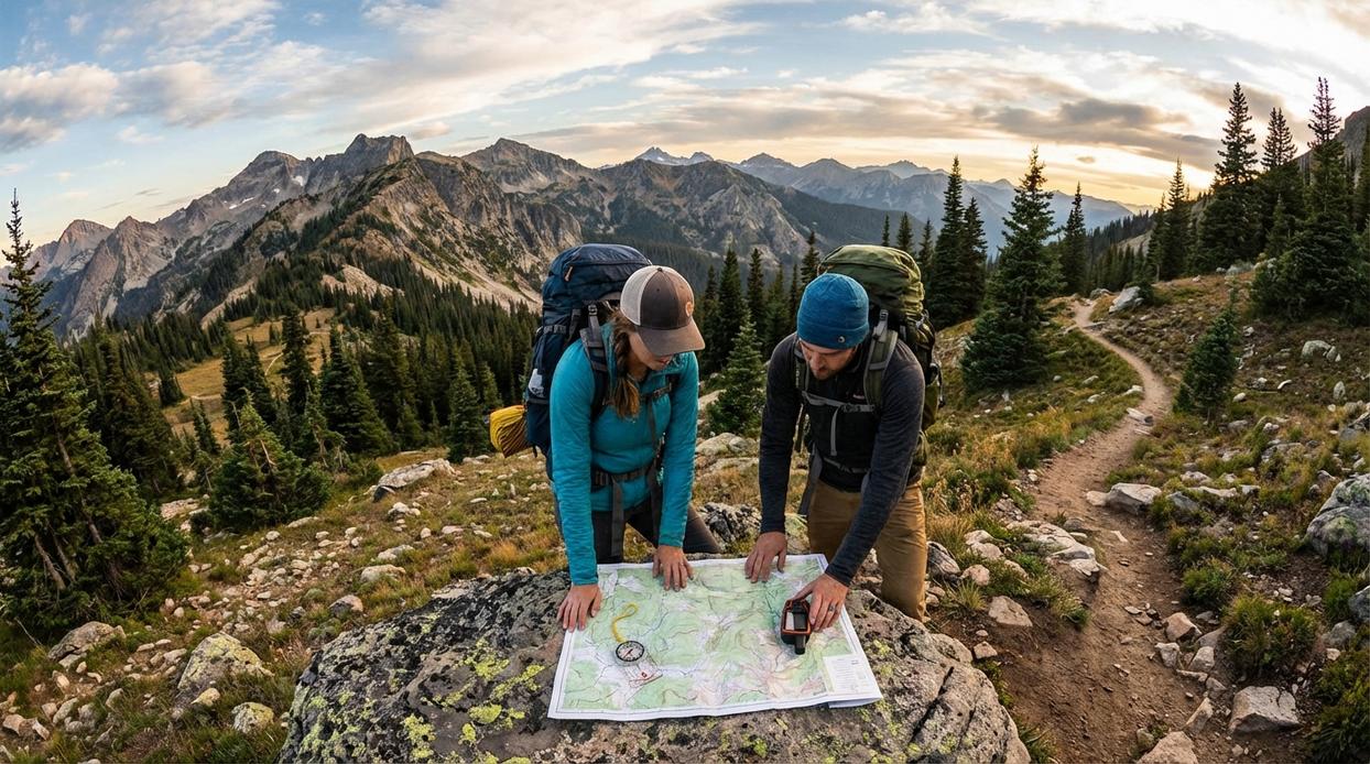
First, plan on a desktop app like CalTopo or Gaia GPS. Why desktop? Bigger screen, better visibility, fewer mistakes. Plot your primary route, add waypoints for water sources, trail junctions, and bailout points, then export the GPX file to your device.
A vs B: planning casually on your phone while packing vs building a precise route on a desktop. One leads to confidence. The other leads to “Wait… was that the ridge?” (Spoiler: it usually is not.) This step is non-negotiable.
Map Downloading for Offline Use
Next, assume zero cell service. Not “weak bars.” Zero. Download multiple layers—topographic (terrain shape), satellite (real-world imagery), and forest service maps (roads and boundaries)—for your entire operational area.
Relying on live data vs fully offline access is the difference between independence and a blinking loading screen. Pro tip: zoom in and pan across your whole route after downloading to confirm tiles are cached.
Power Management Strategy
Now build a power plan. Carry a fully charged power bank (minimum 10,000 mAh), spare batteries if using a dedicated GPS unit, and enable airplane or expedition mode to reduce background drain.
Phone-only setup vs layered power backup? One is convenient. The other is resilient. Cold weather can drain batteries up to 50% faster (Battery University).
Gear Sync & Test
Finally, test everything. Open your downloaded maps. Load the GPX. Simulate navigation.
Because gps navigation in wilderness is only reliable if you confirm it works before you leave home.
On-the-Trail Tactics for Reliable Navigation
Reliable navigation starts before you take your first step. Acquiring a signal lock means allowing your GPS device to connect to multiple satellites for an accurate position fix. In simple terms, a “satellite lock” is when your unit calculates your precise coordinates by triangulating signals from space. For best results, step into a clearing with a wide view of the sky. Avoid canyon walls, dense canopy, or cliff overhangs, which can block or bounce signals (yes, mountains can mess with your tech). Wait until accuracy stabilizes before moving.
Next, read your GPS map intentionally. Orient the map so it matches the terrain in front of you—most devices let you set “north up” or “track up.” Topographic lines (contour lines that show elevation changes) help you visualize hills, ridges, and valleys. Close lines mean steep terrain; wider spacing signals gradual slopes. At trail junctions, pause and compare your plotted route with what’s on the ground. Don’t guess—confirm.
When it comes to dropping waypoints & tracking, be proactive:
- Mark water sources and campsites
- Save tricky intersections
- Pin trailheads and parking areas
Waypoints are saved coordinate markers. Tracking creates a digital breadcrumb trail so you can retrace steps if conditions shift. It’s a core discipline of gps navigation in wilderness travel.
Finally, practice efficient battery use. Turn the device on, check position, then power it off completely. The screen drains the most energy. Pro tip: lower screen brightness before every outing. Smart power management keeps your navigation reliable long after sunset.
And remember, navigation pairs with survival skills—review the science behind fire starting techniques in the wild before heading out.
When Technology Fails: The Analog Backup System
First, remember the Redundancy Rule: a GPS is a tool, not a savior. Screens crack, batteries fade, and water seeps into circuits with a faint metallic smell. gps navigation in wilderness can guide you through fog-draped ridgelines, yet one hard drop onto granite and the silence is absolute.
So, carry the basics.
| Essential Item | Why It Matters |
|---|---|
| Topographic Map | Shows terrain, water, elevation |
| Magnetic Compass | Works without power |
A waterproof map feels crisp in cold fingers; a compass needle hums steady and sure. Ultimately, mastering these core skills means confidence—no batteries required.
Bringing It All Home: Your Pre-Hike Navigation Checklist
By now, you’ve seen that successful navigation is a system, not a single gadget. The real risk isn’t the wilderness; it’s walking in unprepared. A dead battery turns confidence into crisis fast.
So before you lace up, pause and run this checklist:
- Route uploaded to your device?
- Offline maps downloaded and tested?
- Waypoints and exit trails marked?
- Power bank fully charged?
- Spare batteries packed?
- Paper map and compass in your bag?
In short, gps navigation in wilderness works best when backed by preparation. Quick prep today guarantees you return safely tomorrow. Home.
Understanding how GPS navigation functions in remote wilderness areas can greatly enhance your adventure, especially when seeking hidden gems like the breathtaking Havajazon Waterfall – for more details, check out our Where Is Havajazon Waterfall.
Ready for Your Next Wilderness Breakthrough
You set out to master safer, smarter outdoor exploration—and now you have the strategies to do exactly that. From route planning to gear upkeep and gps navigation in wilderness environments, you’re better prepared to handle the uncertainty that once made backcountry travel stressful.
The real risk isn’t the trail—it’s being unprepared. Getting turned around, misreading terrain, or relying on outdated gear can quickly turn an exciting trek into a dangerous situation. But with the right navigation techniques, maintenance habits, and field-tested strategies, you stay in control.
Now it’s time to take action. Upgrade your preparation before your next trip. Review your navigation setup, refine your trekking plan, and equip yourself with proven outdoor essentials trusted by seasoned explorers. Join thousands of adventurers who rely on our expert-backed insights and top-rated gear guidance to explore with confidence.
Don’t wait until you’re off the grid to realize you missed something important. Prepare smarter, trek farther, and step into the wild fully ready for whatever the horizon brings.