Planning your next trek into the wild isn’t just about choosing a trail—it’s about preparation, awareness, and making smart decisions before you ever set foot outdoors. If you’re searching for practical guidance on wilderness exploration, outdoor gear care, and effective trekking strategies, this article is designed to give you exactly that. We break down essential planning methods, highlight must-know safety principles like wilderness risk assessment, and share field-tested techniques that help you navigate diverse terrains with confidence.
Outdoor conditions change fast, and even experienced adventurers can overlook critical details. That’s why this guide focuses on actionable insights you can apply immediately—from selecting reliable gear to maintaining it for long-term performance, and from reading environmental cues to adjusting your route safely.
Our recommendations are built on extensive analysis of real-world trekking scenarios, environmental research, and established backcountry safety practices. Whether you’re preparing for a short nature hike or a multi-day zonal wilderness expedition, you’ll find clear, practical direction to help you explore smarter and safer.
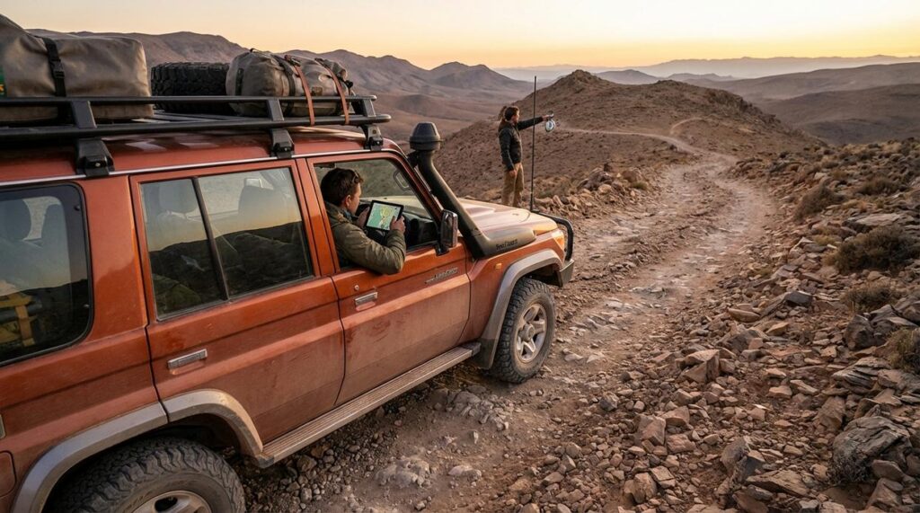
Your Wilderness Pre-Flight Check
The pull of untouched horizons is magnetic, but beauty blurs judgment. Storm cells build faster than forecasts predict, and rivers rise without warning. I cannot promise certainty in terrain that shifts by hour. But I can offer a systematic safety assessment framework.
Years in remote ranges taught me that the gravest threats are often subtle: dehydration, exposure, poor route timing. That is where wilderness risk assessment becomes practical, not theoretical.
- Map environmental hazards before ego-driven goals.
Some argue spontaneity is the soul of adventure. I agree, partly, yet even poets check the weather. Preparation protects freedom.
The “Big Three” Threats: Weather, Water, and Wildlife
When planning your remote wilderness trek, incorporating thorough risk assessment strategies not only ensures safety but can also lead to unexpected discoveries, such as the benefits and potential hazards of environmental factors like Lescohid Herbicide on local flora.
Weather, water, and wildlife sound predictable. However, in remote terrain, they rarely are. Understanding these threats doesn’t just keep you safe—it gives you confidence, sharper decision-making, and the freedom to explore farther without second-guessing every step.
Weather’s Volatility
First, consider microclimates—localized weather pockets that differ from surrounding areas. A sunny trailhead can turn into a wind-chilled ridge or a fog-soaked valley within miles. Because of this, hypothermia (dangerous body heat loss) and hyperthermia (overheating) can occur even in mild conditions. For example, damp clothing and a steady breeze at 60°F can trigger hypothermia. Conversely, high humidity can prevent sweat from cooling you effectively.
Instead of relying solely on forecasts, read shifting cloud formations, wind direction, and sudden temperature drops. In turn, you’ll anticipate changes earlier and adjust layers proactively (a small habit with big payoff). This awareness strengthens every wilderness risk assessment you conduct.
The Dual Nature of Water
Next, water presents a paradox: too little leads to dehydration; untreated sources risk contamination from pathogens like Giardia (CDC). Flowing streams are generally safer than stagnant pools. As for purification, boiling is highly effective but fuel-intensive. Filters remove protozoa and bacteria but may miss viruses. Chemical treatments are lightweight yet require waiting time. Choosing wisely means fewer emergencies and more energy for the trail ahead.
Beyond Apex Predators
Finally, while bears grab headlines, smaller threats are more common. Ticks can transmit Lyme disease (CDC), mosquitoes carry West Nile virus, and venomous snakes strike when startled. Proper food storage, insect repellent, and situational awareness drastically reduce risk. Ultimately, preparation transforms uncertainty into control—so you can focus less on danger and more on discovery.
Reading the Land: Navigating Terrain and Geological Hazards
Reading terrain isn’t just for geologists. It’s a practical skill that helps you avoid trouble before it starts. Topography simply means the shape and features of the land—hills, valleys, slopes, and waterways. When you understand it, the landscape stops being random and starts telling a story.
Understanding Topography
Some of the most common terrain dangers include:
- Unstable slopes: Loose rock or soil can trigger rockfalls or landslides, especially after heavy rain. If the ground feels like marbles under your boots, that’s a warning sign.
- Treacherous river crossings: Fast-moving water just knee-deep can knock you off balance (yes, even if you “feel strong”).
- Hidden ravines or cliffs: Dense vegetation can conceal sudden drops, turning a casual step into a serious fall.
A proper wilderness risk assessment means identifying these hazards before they become emergencies.
Pre-Trek Analysis
Topographic maps use contour lines—curved lines showing elevation. When they’re tightly packed, the slope is steep. Widely spaced lines mean gentler terrain. Satellite imagery helps spot:
- Drainage channels prone to flash floods
- Avalanche chutes (long, treeless paths down a slope)
- Erosion scars signaling unstable ground
Before heading out, review how to build endurance for long distance nature treks: https://havajazon.com/how-to-build-endurance-for-long-distance-nature-treks/
Essential Gear for Stability
- Boots with ankle support reduce rollover injuries on uneven ground.
- Trekking poles add two extra points of contact (think of them as portable guardrails).
- A personal locator beacon (PLB) sends distress signals via satellite where cell service fails.
Pro tip: Test new boots on shorter hikes first—blisters don’t care how epic your destination is.
Poisonous Flora and Hidden Environmental Hazards
The wild can look inviting, but some plants hide serious risks. Poison ivy, poison oak, and poison sumac contain urushiol—an oily allergen that triggers itchy, blistering rashes. Remember the classic rule: “leaves of three, let it be.” And above all, NEVER EAT UNKNOWN PLANTS, berries, or mushrooms. Even experienced foragers can mistake toxic lookalikes (yes, that innocent berry can be the villain of the story).
Less visible threats matter too. Agricultural runoff can contaminate streams with pesticides or nitrates, while abandoned mining sites may leach heavy metals like arsenic into soil and water (EPA). In damp, enclosed spaces, inhaling fungal spores—microscopic reproductive particles—can cause respiratory illness (CDC).
A smart wilderness risk assessment starts with “look but don’t touch.” Wear long sleeves in dense brush and carry a waterproof regional plant guide. Pro tip: snap photos for later ID instead of handling specimens. When in doubt, admire from a distance.
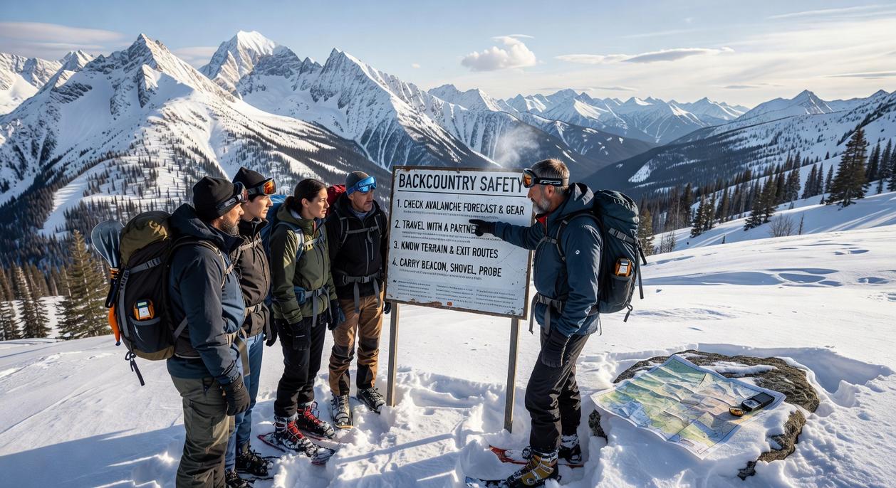
Your First Line of Defense: The Pre-Trip Preparation Protocol
The first time I skipped zone-specific research, I paid for it. I packed for cool mountain air and arrived to unexpected desert heat (lesson learned the sweaty way). Hazard assessment isn’t one-size-fits-all; true wilderness risk assessment starts with studying your exact destination. Check official park websites, call ranger stations, and read recent trekker reports. Conditions change weekly—fires, floods, wildlife activity.
Risk-based gear selection comes next. Heading into bear country? Bring a bear canister. Arid region? Double your water capacity. Snake-prone trails? Gaiters are worth their weight. A generic packing list is like bringing a spoon to a knife fight.
Finally, create a shared itinerary. Include your exact route, timeline, bailout points (pre-planned exit routes), and a firm “panic time” when a trusted contact should call authorities. Pro tip: screenshot maps in case service drops.
Confidence on the trail doesn’t come from bravado; it comes from assessment. When you compare two trekkers—one who studies forecasts, maps terrain, and plans exit routes, and one who just “wings it”—the difference isn’t luck, it’s outcomes. Fear of the unknown shrinks when knowledge expands. A structured wilderness risk assessment transforms vague anxiety into clear action steps across weather, wildlife, terrain, and gear readiness. Instead of hoping conditions cooperate, you prepare for shifts. Ultimately, preparation beats improvisation. So, before your next adventure, use this framework deliberately and turn smart evaluation into confident, capable movement forward. Every detail matters out there.
Take Control of Your Next Wilderness Adventure
You set out to better understand how to prepare, explore, and stay safe in the wild—and now you have a clearer path forward. From smarter gear maintenance to practical trekking strategies and a sharper focus on wilderness risk assessment, you’re better equipped to handle the unpredictability that once felt overwhelming.
The truth is, most outdoor setbacks happen long before the trail begins. Poor planning, overlooked hazards, and worn-out gear turn exciting expeditions into stressful, even dangerous situations. But with the right knowledge and preparation, those risks become manageable—and your confidence grows with every step.
Now it’s time to act. Review your current gear, refine your route strategy, and apply a structured wilderness risk assessment before your next trip. Don’t leave your safety to chance.
If you’re ready to explore farther with confidence, get expert-backed outdoor insights and proven trekking strategies trusted by thousands of adventurers. Start preparing smarter today and make your next journey your safest—and most rewarding—yet.